5/28/08

Forest carbon credits could help development in Congo (DRC)


Forest carbon credits could help development in Congo:

Interview with Nadine Laporte, remote sensing expert

Rhett A. Butler, mongabay.com

May 28, 2008


An initiative to reduce greenhouse gas emissions by offering carbon credits to countries that reduce deforestation may be one of the best mechanisms for promoting sustainable development in Central Africa says a remote sensing expert from the Woods Hole Research Center (WHRC).

Dr. Nadine Laporte, an associate scientist with WHRC who uses remote sensing to analyze land use change in Africa, says that REDD could protect forests, safeguard biodiversity, and improve rural livelihoods in Democratic Republic of Congo (DRC) and other Central African nations.

"REDD is perhaps the most promising way to protect forests in much of the tropics, including all the central African countries," Laporte told mongabay.com. "Carbon credits represent the largest potential flow of revenue to support sustainable development in tropical forest regions, particularly because most of the ecological services provided by these ecosystems (biodiversity, hydrology, sustenance of forest peoples, etc) do not have strong mechanisms to promote their conservation."


Dr. Nadine Laporte
But Laporte cautions that REDD is not a stand-alone solution for development in DRC — it must be integrated into a national program involving the country's emerging industrial sectors. Further REDD will require improved monitoring and governance capacity to be implemented successfully.

"It is necessary to reinforce national capacity to monitor forests and identify the best alternatives to reduce degradation and deforestation, despite wide variation between regions and types of land use," she said. "Moreover, most people in the DRC, for example, rely on fuel wood for their energy needs. As such, it is important to develop REDD programs in synergy with the forest, agriculture and energy sectors."

Laporte says that remote sensing can help the effort by identifying where and why deforestation is occurring; the suitability of land for different types of uses including agriculture; and the carbon stocks of forests. Recently Laporte has used satellite imagery to map the potential for REDD and assess the extent of logging roads in some of the most remote parts of the Congo Basin. In conjunction with the remote sensing, Laporte also works on the ground, training people in central African countries to use satellite remote sensing for forest mapping and monitoring. She engages a wide range of stakeholders including scientists, conservation groups, government forestry departments, forest peoples, and logging firms.

Laporte discussed these projects and more in a May 2008 interview with mongabay.com.


Mongabay: What is your area of research?


Nadine Laporte with Olivier Desmet CIB Forest Management Unit in a logging concession
Nadine Laporte: Most of my research is focused on the application of satellite imagery to the monitoring and management of tropical forest ecosystems, including vegetation mapping, land-use change analysis and modeling the impacts of these changes on biodiversity and the carbon cycle. I also focus on training people in central African countries to use satellite remote sensing for forest mapping and monitoring, including those working for National Forest Services, and biologists and ecologists working for international conservation organizations in parks and protected areas. I work with foresters in private logging companies as well, including the Congolaise Internationale des Bois (CIB).


Mongabay: Is most of your work done in the field, via remote sensing, or a combination of the two?


Forest management maps from CIB logging concession + web site address CIB


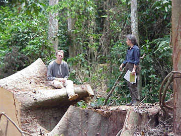
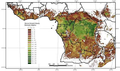
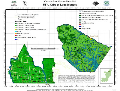
Nadine Laporte: My group uses a combination of satellite imagery integrated with field information. We rely on field information for the calibration of our models and also for the validation of our results. To produce our maps of the distribution of above-ground biomass of tropical Africa, for example, we collected field information from foresters and national institutions. In the Republic of Congo some of our remote sensing analyses have been used to develop national mapping standards for forest management plans. In the DRC our biomass map was used to calculate the level of compensation necessary reduce emissions from deforestation.


Mongabay: How did you become involved in the work you do today?

Nadine Laporte: I studied tropical biology in Toulouse France, when the French space program was just getting started. Using satellite imagery for monitoring tropical forests appeared to me an ideal area of applied research, and I decided to study forests from space. Remote sensing was not taught at the University (Paul Sabatier) yet, but I was able to get an internship in the Laboratory for International Mapping run by a Professor Blasco. At the time they had one computer as large a Fiat and I started learning the basics of satellite remote sensing analysis. I have always been fascinated with tropical forests, and working on better forest conservation and management has become ever more critical as conversion to crops and pasture continues to increase in most tropical countries.


Mongabay: Given the state of infrastructure in DR Congo, is remote sensing an effective way to monitor remote parks in the country? What can remote sensing tell you beyond the extent of forest cover?


Forest management maps from CIB logging concession + web site address CIB
Nadine Laporte: The extent and remoteness of DRC's dense humid forest makes remote sensing an essential tool for monitoring and mapping - in fact it is the only feasible way to do so. For example, using Landsat imagery we were able to map the expansion of roads across all of central Africa (see Laporte et al. 2007, Expansion of industrial logging in Central Africa. Science 316:1451). We were also able to map biomass across the continent. This biomass map (the first of its kind) was derived using imagery from the MODIS sensor and a large set of field measurements (see Baccini et al. 2008, A first map of tropical Africa's above-ground biomass derived from satellite imagery, Environment Research Letters, online). The spatial distribution of biomass is a key element in efforts to reduce uncertainty in the global carbon balance and in quantifying carbon emissions associated with land cover change for the emerging carbon markets.


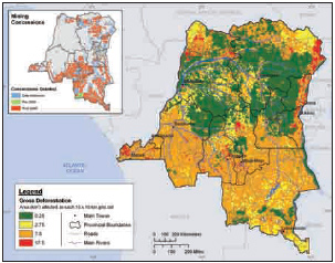
Mongabay: You recently completed a preliminary assessment for the potential of REDD in DR Congo. Can you highlight some of your findings?

Nadine Laporte: We found that more than 17 billion metric tons of carbon are stored in above-ground biomass across the DRC. During the period 1990-2000, the annual CO2 emissions from deforestation were estimated to be 226 million tons. Some of this carbon is not immediately released to the atmosphere but remains as dead wood or as wood products removed from the forest, both of which have slower decay and emission rates. We estimated that for a 50 percent reduction in carbon emissions, total rural household compensation would likely range between $120 million to $400 million per year for 10 years, depending on the level of compensation required (i.e. between $300 and $1000 per household per year). The mean carbon price to accomplish this compensation would range from $19 to $65 per ton with, importantly, more than 30 million tons of carbon available to the carbon markets for less than $10 per ton. Carbon credits represent the largest potential flow of revenue to support sustainable development in tropical forest regions, particularly because most of the ecological services provided by these ecosystems (biodiversity, hydrology, sustenance of forest peoples, etc) do not have strong mechanisms to promote their conservation. In the DRC, we are focusing on building capacity in the government and with civil society to take advantage of this new mechanism.


Mongabay: Do you see REDD as a viable form of land use in DR Congo for the future? Will REDD be a good way to protect forests in the region?


Distribution of deforestation and mining concessions (insert-top-left) in the DRC. Economic necessity and a potentially vast income from mining epitomize the trade-off s between development and resource protection faced by the DRC. Deforestation in the DRC is in large part a result of household clearing for slash-and-burn agriculture.
Nadine Laporte: REDD is perhaps the most promising way to protect forests in much of the tropics, including all the central African countries. REDD mechanisms are designed to reduce emissions by discouraging deforestation and forest degradation, and as such it is a way to modify land use - but is not a form of land use itself. In April 2008 we organized the first DRC workshop on REDD, in Kinshasa, in collaboration with the Ministry of the Environment and other DRC ministries, NGOs and members of civil society present (ranging from congressmen to slash and burn agriculturalists). During the discussions, one of the conditions for a successful REDD program in the DRC arose as a mechanism to link REDD programs within ongoing national development and conservation programs. It also became clear that it is necessary to reinforce national capacity to monitor forests and identify the best alternatives to reduce degradation and deforestation, despite wide variation between regions and types of land use. Moreover, most people in the DRC, for example, rely on fuel wood for their energy needs. As such, it is important to develop REDD programs in synergy with the forest, agriculture and energy sectors. One potentially huge energy resource for the DRC is nationwide electrification using power generated from the Inga Dam, downstream of Kinshasa, which could produce enough energy for the entire country and still have reserves for export to neighboring countries. Some additional recommendations are available in the report we prepared for Bali on reducing CO2 emissions from deforestation and forest degradation in the Democratic Republic of the Congo (Laporte et al. 2007; released by the Woods Hole Research Center at the United Nations Framework Convention on Climate Change (UNFCCC) Conference of the Parties (COP), Thirteenth session 3-14 December 2007, Bali Indonesia).


Mongabay: Beyond REDD, do you recommend other ways to protect forests and wildlife in DR Congo


Central African rainforest road. Photo by Nadine Laporte.
Nadine Laporte: Reforestation projects in the DRC have been limited but agro-forestry Clean Development Mechanism (CDM) projects can augment and complement REDD mechanisms. The protection of forests at high risk of deforestation will be a high priority for REDD. By protecting carbon stored in forest biomass in the region we are not only protecting the global climate system from further disruption, but also protecting habitats for biodiversity and forest peoples alike.


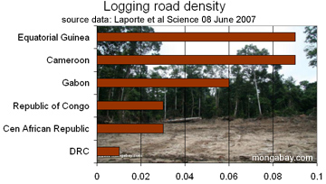
Mongabay: You have published some interesting research on the role of logging roads on market hunting in the Congo Basin. Is logging likely to continue being a driver of poaching in the region? Will logging roads facilitate the development of agro industry in forest areas?


Logging road density in Congo countries.
Nadine Laporte: Opening roads in forested areas increases the risk of deforestation and poaching where human population densities are high by creating better market access for the goods produced from converted forests. It is therefore very important to develop alternative uses of the land, working with rural populations, when new roads are planned, created or restored. If a national infrastructure program is launched in the DRC without an appropriate rural development program, e.g. to help farmers find land use alternatives or a way to intensify their agriculture, it is likely that deforestation and poaching will increase. REDD mechanisms can provide some funds to reduce the deforestation but incentives for local populations are critical, as are rewards for proper management via forest harvesting techniques - including road abandonment and reduced impact logging. Because the agro-industry sector is likely to increase in the DRC we are working to encourage responsible and sustainable forestry rather than wholesale conversion of valuable forests to, for example, industrial palm oil plantations. These plantations could rapidly expand in the region as a result of intensive Chinese investment and the increasing price and demand for oil. We need to help the government to identify the best development scenarios that will minimize C02 emissions but also favor development. Some scenarios to address this are explored in our Bali report.


Mongabay: Do you have any advice for students wishing to follow in your footsteps?

Nadine Laporte: I would recommend students to volunteer in research labs and various projects in the tropics. The need has never been more urgent or the timing more critical. We have only one blue planet - and who wants to live on Mars?


Mongabay: What is your favorite place in the tropics?

Nadine Laporte: I don't have any particular favorite - there are many places that are unique and special in their own way, and each contributes to the diversity of life and cultures in Central Africa.


--
Jean-Louis Kayitenkore
Procurement Consultant
Gsm: +250-08470205
Home: +250-55104140
P.O. Box 3867
Kigali-Rwanda
East Africa
Blog: http://www.cepgl.blogspot.com
Skype ID : Kayisa66

No comments:

Post a Comment